Hills and Mountains are a creation of violent eruptive formations and the gradual process of erosion. However, they are still not very permanent and ever-lasting. Other processes of erosion like Landslides are a part of the natural phenomenon that contributes to the changes in the mountains/hills. The landslide threats are increasing due to enhanced developments in vulnerable terrain, construction activity, climate change, deforestation, etc. However, a forewarning system along with prediction can help curb and control landslides, thereby considerably reducing the destruction caused.
Advances in geotechnical instrumentation, surveying technologies, and data transmission systems have made it possible to monitor slopes remotely. The economic monitoring systems also provide warnings and alarms in case of any failure or unusual behavior.
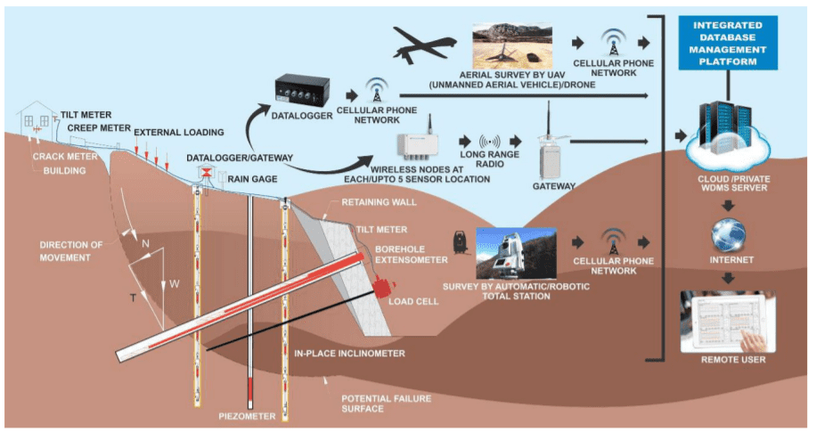
Remote monitoring of slope movement and other parameters can reduce the risk of an unstable or potentially unstable slope. Landslide monitoring helps to prevent any mishaps and accidents. Vibrating wire piezometers can be used for the accurate measurement of pore water pressure. The lateral movement and deformation can be estimated with the help of sensors like in-place inclinometers, extensometers, crack meters, tiltmeters, etc.
The geotechnical instruments are connected to a data logger that records the readings at regular intervals. In case the output surpasses the selected intervals, it will trigger an alarm and send out an alert message to the required authorities. Data can be transferred using SDI-12 bus, cellular network, or radiofrequency technologies, depending on site conditions.
The collected data is then evaluated by an engineering geologist and consultant, allowing them to take corrective measures and prevent landslides.
Read more: Wireless Technology in Landslide Monitoring
Landslide Monitoring & Instrumentation – Why do we need it?
Landslide monitoring and instrumentation are extremely crucial for the safety of the surrounding areas and people. Here are a few steps that can be adopted in landslide-prone areas:
- Monitoring the slope for any hint of instability can help perform remedial measures even before alarm conditions are generated.
- Slope Stabilization Techniques can be employed to stabilize slopes that need corrective action.
- Curate an online monitoring program to ensure that the stability of the slope is accomplished.
Landslide monitoring involves the usage of a durable prediction and forewarning system, coupled with effective efforts to curb slope movement. The destruction can be drastically reduced with the help of monitoring and instrumentation. A reliable plan for corrective and preventive measures in a landslide or prone area must be based on a detailed integrated geological and geotechnical investigation and monitoring.
An engineering geologist is essential to evaluate the type of landslide and perform corrected measures based on the data collected during the monitoring period. The solution plan should take the cost and effectiveness into consideration.
Solutions Available for Landslide/Slope Monitoring
Encardio Rite offers a simple to use, complete, and cost-effective solution, for online monitoring of landslide-prone areas. This comprises supply, installation, calibration, data collection, maintenance, and a web-based data monitoring service that presents information in the most suitable form for easy interpretation of the monitoring data.
Here are the solutions available with Encardio Rite for online landslide monitoring:
- Geotechnical Instruments for the measurement of all the relevant parameters needed for landslide/slope monitoring.
- Automatic monitoring of geotechnical sensors using SDI-12 digital interface data logger with GSM/GPRS telemetry.
- Automatic monitoring of instruments with the help of LoRa nodes and gateway.
- Geodetic monitoring with automatic total stations with GSM/ GPRS telemetry.
- Web data management service (WDMS) that presents data online (with alarms) to authorized users at different locations on their devices.
Landslide Monitoring instrumentation
Encardio Rite stocks a range of instruments for surface and subsurface online monitoring that include:
(a) Sub-surface instruments
- Subsurface lateral movement monitoring can be done with in-place inclinometers.
- Pore water pressure variations and monitoring of the landslide area are carried on by piezometers.
- Borehole extensometers are used for the monitoring of sub-surface settlements at specified points.
(b) Surface Instruments
- Tiltmeters are used in one or more locations of the retaining wall/building falling within the zone of influence. It measures any change in slope inclination near cracks and areas of maximum anticipated rotational movement.
- Landslide instrumentation makes use of crack and joint meters for accurate monitoring of displacement/opening of cracks in the rock mass, buildings, and structures.
- Creep meter with invar wire for monitoring displacement/opening of faults in the ground.
- Tension in anchors is monitored with the help of the center hole load cell.
- Rain gauge for monitoring rainfall.
Datalogging, data transfer, and online monitoring
- Data Loggers are available with an integral GSM/GPRS modem for transmitting data to a central server.
- Web-based data management systems with suitable software
Surveying
Automatic Total stations and control boxes are equipped with a GSM/GPRS modem for data transmission to a central server.
Data Transmission Options
SDI-12 interface real-time monitoring
Encardio Rite offers advanced automatic data loggers with GSM/GPRS for data collection. It is used in geotechnical instruments with an SDI-12 digital interface and transmits the data to a remote server.
Take a look at the diagram below.
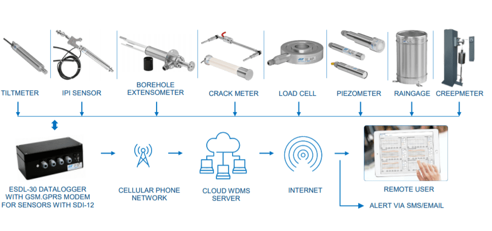
Encardio Rite system offers the advantage that only a single 3-conductor cable interconnects all the sensors and the data logger in a serial bus. SDI-12 is a multi-drop interface that can communicate with multi-parameter sensors.
The data logger can be programmed to take a measurement ranging from just 5 seconds to 168 hours. For better battery life, it is advised to transfer the data logged 2-4 times/day. The measured data is stored, together with the current date, time, and battery voltage, as a data record in the internal non-volatile memory of the data logger.
The landslide monitoring solution offered is not an expensive option. It is just a small fraction of what we spend on rescue operations, debris removal, and rehabilitation. The slop movement monitoring provides corrective action that may help avoid the occurrence of the landslide. Proper implementation of drainage for groundwater, anchor bolts and cable anchors, pressure grouting, etc. makes it possible to curb the landslide to a large extent. In cases where it is not possible to prevent a landslide, the data collected may give sufficient time for evacuation.